Ongoing debates in the fields of photography and visual culture over the past decades have been concerned with the relationship of viewers to single images and photojournalistic trophy shots, questioning the ability of such documentary images to convey the pain of others or generate effective calls for action.
Today, the sheer amount of moving and still images generated around major incidents and circulating in the digital realm, means that to truly engage with the circumstances under which an incident occurred requires reconstructing relations between parts of a much wider assembly. While the IMAGE COMPLEX refers to these relations between images, it also indicates how such relations are points of mediation between multiple actors – the people, companies and agencies producing, broadcasting, viewing, analysing, decoding, assembling, modelling and acting upon images.
Videos of incidents that go viral online are often those that contain within a single frame both perpetrator and victim. Yet for every image that includes a complete scene there are dozens that include only part of it, or just audio, or things that happened before or after the incident. Their relation to other images and to the violent incident is not obvious. It is harder to understand incidents that slip between dozens, sometimes hundreds of images that are often discarded as irrelevant.
Reading such incidents requires the construction of a navigable three-dimensional space, and the composition within this space of all possible relations between images – thus, architecture. THE ARCHITECTURAL IMAGE COMPLEX is a method used by Forensic Architecture to locate and view multiple images and videos in 3D models of built-up environments. Such models allow the investigator to navigate from one image or video to another. Single images are therefore studied not only for the evidentiary details that can be found in them, but for visual hinges that link them to others.
If in past decades human rights research was limited by the scarcity of sources and evidence, at present the availability of large quantities of images, videos and data around an incident can create the opposite problem – how to manage this material, and generate insights from overabundance.
Pattern analysis originated in risk management and has been weaponized by the CIA through pre-emptive drone strikes. It can however be repurposed to investigate such state violence. Pattern analysis allows researchers to establish otherwise invisible correlations, clusters, and associations between incidents – modes and frequencies, trends and phase transitions – or to assess instances where information is repeatedly obscured or denied by the military or other state agencies. Such patterns allow lawyers to attribute violations to modes of operation or official policies, rather than to individual decisions.
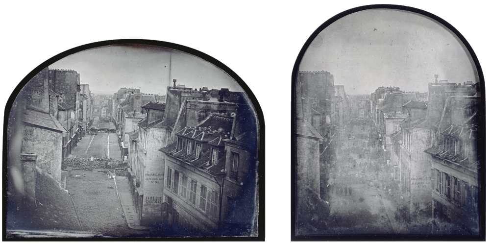
Eugène Thibault, The Barricade in rue Saint-Maur-Popincourt before and after the attack by General Lamoricière’s troops. 25 and 26 June 1848. Images courtesy of Musée d’Orsay / Réunion des musées nationaux.
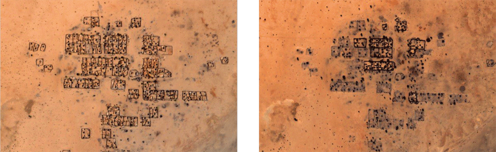
Before and after satellite images showing destruction of the village of Shangil Tobaya in North Darfur, Sudan, during the ethnic cleansing of non-Arab Dafuri’s by government-armed and funded Arab militias. 10 March 2003 and 18 December 2006.
Before-and-after photographs are the very embodiment of a forensic time. Two still frames seek to describe a missing event by showing the states that preceded and followed it. This form of presentation emerged out of the limitations of the early photographic process. The few dozen seconds required for the exposure of a mid-nineteenth century photograph was too long to record moving figures and sudden events. The result was that people were usually blurred against the background of the image – only static elements of the urban fabric could be registered.
Today, some of the most common before-and-after images come from satellites, the temporal rhythm of their orbits meaning that specific events are often missed. The resolution of publicly available satellite imagery is limited to 50cm per pixel, which means that a single pixel masks the human body. This ‘threshold of detectability’ means that, 150 years after the invention of photography, the original condition persists: the human figure and events are dissolved into the ground of buildings, cities, or territories. The text above draws on research conducted with Ines Weizman.
In 2017, Amnesty International and Forensic Architecture worked together to expose the routine practice by Cameroonian forces at two military bases in northern Cameroon of illegal detention, torture and execution of people accused of supporting Boko Haram. A digital model of the base was built from satellite imagery to establish the precise location of a series of ground-level images, including those taken by a US military contractor at the Salak military base and uploaded to Facebook in April and May 2017. Some of these images confirm that US personnel had access to areas of the base only metres away from sites of interrogation and torture, raising questions as to how much the US personnel cooperated in or knew of the torture.
Using Forensic Architecture’s models, Amnesty International’s 2017 report ‘Cameroon’s Secret Torture Chambers’ led to two separate internal investigations by the US Army and US Special Operations Command.
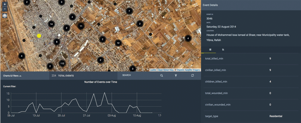
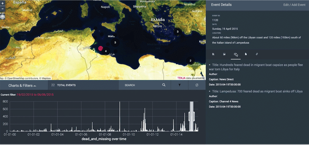
Top: ‘The Gaza Platform’: an interactive map of Israeli attacks during the 2014 Gaza conflict, which found patterns within more than 2300 incidents during the war. Data collected and shared by the Al-Mezan Center for Human Rights, The Palestinian Center for Human Rights, and Amnesty International. Bottom: ‘Fortress Europe: Visualization of the Migrants’ Files’ datasets. The Migrants’ Files is a consortium of journalists from fifteen European countries that collect data on people who died trying to reach or stay in Europe.
Beginning in 2014, Forensic Architecture developed an open-source software called PATTRN (coordinated by Francesco Sebregondi), a crowdsourcing device that allows activists to upload information and then map relations between discrete events, identifying patterns and trends in time and space. The aim was to support the sharing and collation of first-hand reports of events on the ground by the very people who are subjected to violence, to assemble reports and produce analysis. Verification can be undertaken not by tracing the provenance of evidence back to the identity of users (which could be dangerous for them and would render the tool vulnerable in court), but by peer-to-peer correction with minimal editorial oversight.